Development of Sustainable Homes Through Renewable Energy Sources
February 27, 2021
How does the Composition of Cement Affect the Design of Civil Engineering Structures?
February 27, 2021Introduction
The aim of this paper is to identify the exact pipeline route within the route corridor provided by Pipealot Ltd following their initial feasibility study. The study will look into environmental constraints associated to the identification and construction of the exact route on the map provided by Pipealot Ltd.
An Environmental Impact Assessment (EIA) is required for this project as the environmental consequences whether positive or negative have to be predicted to decide whether or not to proceed with the project. It is absolutely vital to make sure that the impacts of the projects are at an acceptable level in terms of the changes/disorder caused to the environment. Since a new steel oil pipeline has to be installed, there is a need to select the exact route for it and therefore the EIA is required to be performed to identify the extent of impacts of this network in areas where environmental risks are significant (CBP, 2012).
The oil pipeline operations and construction promotes serious environmental and social effects. Undertaking respective measure is the best cost effective method for dealing with the effects in the first steps (planning phase) of the project of oil pipeline. Carrying out the assessment of the environmental impact (EIA procedure) is one of the undertaking measures. When the undertaken measure is legal and in conformity with the public participation that is implied by the good practice, it comes out to be in the interest of all concerned parties (CBP, 2012). The key idea is to investigate the environmental impacts during planning and design phases of the project, thus finding different ways to mitigate these impacts in order to prevent the environment. This practice will also provide decision makers with reasonable forecasts and predictions to make their final decision (BSI, 2014).
Another objective of this study is to choose or prepare a design/route that causes minimum disturbance to the areas rich in populations and infrastructure to protect the environment during the construction process. The selected pipeline route should not, at any cost, go through the areas rich in population and should stay as far away from these sensitive places as possible. The public participation PP is a required element of any executed and regulated EIA procedure.
Key Aims and Objectives
The key objective of this paper is to identify Environmental impacts in relation to the construction of oil pipeline. Following are the environmental constraints that need to be dealt with as part of the pipeline route selection procedure:
- Increased Public Awareness
- Limiting of the project progress due to the increased public awareness
- Dangers and hazards associated to the construction and maintenance of oil transporting pipelines
- Avoiding scientific sites, natural reserves such as woodlands, natural parks, birds sites and heritage that exist through the suggested corridor.
- Regulations with respect to the approval of the shape of the new pipelines as they pass through densely populated areas or districts
- Pipeline material selection
- Identify best location for pressure testing station
- Provision of Public Consultation plan for private or public land owners and occupiers
Pipeline route selection
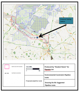
According to the project specifications, the pipeline route should also incorporate site for a pressure testing station. The purpose of having a pressure testing station is to ensure safety and maintenance of the pipeline, minimizing the risk of damage to the property and public. The testing Drawing number 6 shows that possible location of the pressure testing station in an area far from natural habitats, heritage, birds sites, scientific interest sites and natural reserves. Overall, the key aim of the pipeline route selection process is to keep the capital and maintenance costs on the lower side as well as cause minimum disturbance to the general public and governmental projects during the construction phase (Pipeline Route Selection, 2014). The proposed pipeline route itself also avoids habitat, natural and national reserves, woodlands, gardens, parks, sites of special interest, monuments, special sites of conservations, and scientific sites.
“The selected route should be recorded on alignment sheets of an appropriate scale. The coordinates of all significant points, such as target points, crossings points, bend starting and end points, should be indicated. Contour lines should be recorded at intervals sufficient for design purposes, particularly with regard to the installation and operational phases, and consideration should be given to the need for a vertical profile of the route”, as stated by Guy Henley (2012).
Maps were generated for all environmental constraints including heritage, natural reserves, sites of scientific interest, natural reserves and agricultural land to ensure to ensure the environmental constraints are within the approved limits.
Pipeline material and specification
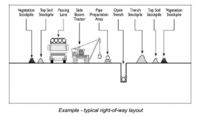
The new pipeline shall be 600mm in size and the working area shall not be more than 50 meters in width. The method used for the purpose of installing the pipeline will be according to the industry best practices. The new oil pipeline will be made of steel due to the advantages such as strength, reliability and recycling.
Potential Environmental impacts of oil pipeline
Following are the potential environmental impacts that can occur as a direct result of the construction of oil pipeline within the suggested corridor:
- Damage to the infrastructure when installing the new pipeline along the proposed route
- Leaks from the pipeline can cause severe water pollution if not dealt with properly
- Soil sedimentation issues along the route of the pipeline
- Release of greenhouse gases from the road vehicles during the lengthy construction phase of the project
- Safety hazards to the animals and humans inhabiting in the region
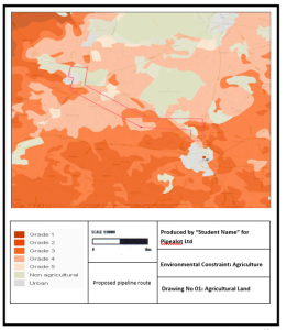
- From the drawing number 1, it is evident that the pipeline route passes through the corridor that entails grade 1, 2 and 3 agricultural lands.
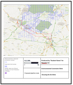
- From the drawing number 2, the pipeline route involves special interest areas and important bird areas. These sites could be affected by the construction of the pipeline or any oil leakages that occur in the future. (Sitemap UK, 2014)
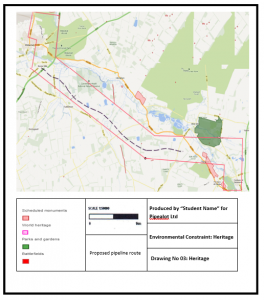
- Parks, gardens and scheduled monuments are there in the suggested corridor. The impact of pipeline construction and operation on the heritage sites will be avoided at all costs.
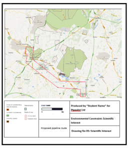
- Sites of special scientific interest and special areas of conservation are also presented in the suggested corridor. The construction of oil pipeline will have a substantial environmental impact on these.
- National parks and ancient woodlands also exist through the corridor and will be avoided.
- The suggested route runs directly through the site of special scientific interest near the Tuddenham area, as evident from the drawing 6.
- The pipeline route runs through important bird areas (with sites for endangered species), which would be at risk due to accidents such as oil spills. Large scale constructionand forest clearance will be required tofacilitate the construction of the that can led result in oil spills (English Heritage, 2014)
- Special areas of conservation and national natural reserves also exist within the corridor as another environmental impact and the suggested route runs close to them.
- Impacts associated to the location of pressure testing center (Sitemap UK, 2014)
Mitigation Ideas
To be able to reduce the potential negative impacts of the new oil pipeline along the proposed corridor, the following mitigation strategies during the construction and operational phase of the pipeline could be employed (Pipeline route selection process, 2012). The aim of these mitigation is to avoid certain types of environmental impacts occurring or, where impacts are unavoidable, reduce their potential significance to acceptable levels.
- The proposed route of the pipeline runs directly through the Site of Special Scientific Interest near the Tuddenham area and therefore the impacts associated to the movement of vehicles and personal and dust particles will be minimized with the help of industry best construction code of practice. Furthermore, awareness training will be provided to the construction staff to minimize the risk of accidents. Monitoring program will also be introduced to ensure there are no long term effects on the nature conservation. (Environment Agency, 2014)
- Route of pipeline should be modified to avoid high risk areas such as populated districts, SSSI, birds sites, heritage sites, national parks, natural reserves, woodlands etc.
- The constraints relative to the design and construction process and environmental conditions are specified with the help of a series of maps which is attached to this report.
- Steel as the pipeline material can be replaced with an anti-corrosion material, within the specified budget, if possible
- There is a need to put up warning/awareness signs regarding the pipeline installation for general public for the purpose of safety
- Maintenance on the oil pipeline should be performed on a regular basis to avoid pressure build up, corrosion and leakage.
- At the pressure testing facility, there is a need to notify station personnel of areas to be avoided due to the risks associated to pressure testing
- There should be no high pressure testing in the work centers
- During the pressurization, the person performing the test needs to stand behind the barrier
- Follow the HAZOP rules as per the industry best practices (Pipeline route selection process, 2012)
- Consultation with the UK’s department of Bird Life will be done to discuss the nature of the birds occupying the area of important bird sites that is running through across the width of the proposed corridor. Permission from the UK’s department of Bird Life will be required before the beginning of the construction phase.
- Special areas of conservation and national natural reserves in the corridor will be avoided as the proposed route is positioned far away from them.
- Pressure testing station is positioned far from the natural habitats, SSSIs, natural reserves, monuments, parks and gardens (Pipeline Construction Process, 2012)
Results from environmental impact assessment
The EIA Mapping series attached to the paper section shows that there are environmental factors to be dealt with along the suggested exact route of the pipeline. However, since the chosen corridor does not pass through densely populated areas, there is no need to look for alternative pipeline route. As briefly discussed before, the shortest possible route is selected whilst avoiding any risks of environmental impacts. However, even after the installation of the pipeline, maintenance works will be required on a regular basis to prevent oil leaks, dangerous liquid pressure inside the bending pipeline, contamination of soil and safety risks to humans or animals. Environmental impacts have been reviewed in detail to minimize the hazards, accidents and long terms effects particularly where the route runs through heritage sites, bird sites, natural reserves and area of special interest. Furthermore, the approved construction practices will be following during the construction phase. As indicated before, the route corridor involves a large important bird sites area and therefore permission from the UKs department of Bird Life must be obtained to commence the construction activities. If the permission is not granted, a different route corridor will have to be employed.
Public Consultation Plan
Consultation Commitment
The approach to complete this project will incorporate compliance to the laws, operational excellence and industry best business practices. The surrounding communicates in which operations will be performed will be supported and engaged. This pipeline plan has been developed as per the Pipelines Act 2005 (Preparation of Pipeline consultation plans, Guidelines).
Objectives
- Timely distribution of project information to the concerned parties including the occupiers and landowners as this practice will ensure better understanding of the project and mitigation strategies of environmental impacts
- To notify the occupiers and landowners of the consultation procedures used by the project
- A continuous consultative procedure will be used during the project
- To understand the concerns and views of landowners and occupiers and to be open to their suggestions for the project
- Ensuring consistency with regulatory requirements by outlining the consultative process with occupiers and land owners (PIPELINE CONSULTATION PLAN, 2013)
Implementation
- Establishing good relationships will all occupiers and land owners and ensure provision of accurate information to them
- Provide any documents of concern and to give feedback on any agreed terms and conditions of the contract
- Public Land Agencies including the Local Government, Road Authorities, Rail Authorities, Primary Industries and Department of Environment will be consulted consistently and provided with accurate information on the project (PIPELINE CONSULTATION PLAN, 2013)
Public Consultation Plan Documentation
Following documents will be prepared for the public and private landowners and occupiers
- General Survey Information
- List of potential Impacts and their assessment and documents entailing ideas in regards to how would they be managed (Construction Environment Management Plan, Construction Safety Management Plan, Cultural Heritage Management Plan, Operations Environment Management Plan
- Documentation on the project introduction material
- A notice of intention to enter the land for the purpose of survey
- A notice of Pipeline Corridor
- Rehabilitation of Easement
- Application to Alter Authorized Route if required
- Overview of Construction
Consultation methods
- Letters
- Website
- Face to face meetings and discussions
- Display of regulatory signs and documentation (PIPELINE CONSULTATION PLAN, 2013)
Construction Plan
Trenching: Final technique will be decided after consultation with the contractor. Excavator and rotary trenching machine are the typical techniques employed.
Horizontal Directional Drilling: Will be performed if the trenching method is not suitable to the conditions
Welding to join the lengths of the pipe as per the restrictions and regulations
Documents detailing the lowering in, backfill, easement rehabilitation and hydro testing will be prepared and made public, Pipelines Act 2005
Recommendations and Conclusions
From the maps prepared with the help of Microsoft word and Street Maps software, it was made possible to review the environmental constrains along the selected route of the pipeline. The pipeline route corridor involves areas of special scientific interest, woodlands, national parks, gardens, monuments, and birds, which can be considered as an adverse case. The suggested route takes into account the associated environmental impacts after reviewing the impacts in detail. Recommended mitigation strategies have been proposed to minimize the impact on important bird sites, sites of special interest, monuments, parks and gardens and national natural reserves. The series of maps attached to this report can be referred to for detailed information on how the environmental impacts are identified (BSI, 2014). Public consultation plan will is provided for the regulatory authorities to ensure smooth project completion. Accurate information on the project will be provided to the land owners and occupiers in acceptable format. Furthermore, construction procedures will also be shared and employed only after they are approved by the all the concerned parties.
References
- British Standards Institute, Available at http://www.bsi.org.uk/, [Accessed on July 19th, 2014]
- Construction Best Practice Programme , Available at http://www.cbpp.org.uk/cbpp/, [Accessed on July 19th, 2014]
- Environment Agency, Available at http://www.environment-agency.gov.uk/ , http://www.cbpp.org.uk/cbpp/, [Accessed on July 19th, 2014]
- Ordinance Survey Limited, Streep Map Software, Available at https://www.ordnancesurvey.co.uk/opendatadownload/products.html, http://www.cbpp.org.uk/cbpp/, [Accessed on July 19th, 2014]
- Pipeline Route Selection, Available at, http://www.oilandgastechnology.net/pipeline-news/pipeline-route-selection-%E2%80%93-route-success, http://www.cbpp.org.uk/cbpp/, [Accessed on July 19th, 2014]
- Pipeline route selection process, Available at https://www.enbridgegas.com/assets/docs/4.0%20Route%20Selection%20Process%20-%20Redacted%20(Ottawa).pdf, http://www.cbpp.org.uk/cbpp/, [Accessed on July 19th, 2014]
- Pressure Testing Station Specifications, https://www.nsf.gov/about/contracting/rfqs/support_ant/docs/facility_manuals/palmer_mcm_and_southpole/pipingpressuretest-706.pdf, http://www.cbpp.org.uk/cbpp/, [Accessed on July 19th, 2014]
- International Association for Impact Assessment, available at http://ndsuext.nodak.edu/IAIA/, [Accessed on July 19th, 2014]
- British Standards Institute, available at http://www.bsi.org.uk/, [Accessed on July 19th, 2014]
- Construction Best Practice Programme, available at http://www.cbpp.org.uk/cbpp/, [Accessed on July 19th, 2014]
- Institute of Environmental Management and Assessment, available at http://www.iema.net/index2.htm , [Accessed on July 19th, 2014]
- Environment Agency, available at http://www.environment-agency.gov.uk/, [Accessed on July 19th, 2014]
- English Heritage, available at http://www.english-heritage.org.uk/discover/your-heritage/, [Accessed on July 19th, 2014]
- Pipeline Public Consultation Plan, available at http://www.exxonmobil.com/Australia-English/PA/Files/pipeline_consultation_plan.pdf, [Accessed on July 19th, 2014]
- Pipeline Route Selection, available at https://www.rwe.com/web/cms/mediablob/en/511550/data/53338/1/rwe-dea-uk/responsibility/RWE-Dea-UK-Breagh-Onshore-Environmental-Statement.pdf, [Accessed on July 19th, 2014]
- Environmental constraints mapping, available at http://sketchmap.co.uk/, [Accessed on July 19th, 2014].
Maps Series
Get 3+ Free Dissertation Topics within 24 hours?


